Our Directional Surveying Methodology for Diamond Drilling
Combining the right tools with the right practices can have a huge impact on productivity, accuracy and system longevity when surveying. Here we break down our exact recommendations on selecting and getting the most out of your survey products in the application of diamond drilling.

Table Of Contents:
Get to know us
The System
Rig Alignment And Starting Direction
Since Downhole Surveys Senior Technical Advisor, Mike Ayris developed the first portable north seeking FOG aligner for drill rigs in 2012, using such a device has become integral to drill rig setup accuracy and overall productivity in exploration mining. When introduced to the industry, the product offered solutions to a time-consuming and often inaccurate process of using land surveyors to mark out azimuths with pegs, posts and flagging tape, to which a driller must align their rig. Not only that, but it provided a high precision answer to drill rig alignment underground.
As technology continued to evolve Devico introduced the DeviAligner, a now key component of our complete survey system for many types of drilling.
-jpg.jpeg)
DeviAligner
The DeviAligner is a high precision north seeking fibre optic gyro used for extremely accurate and fast rig alignment, and for providing an accurate starting direction to the DeviGyro (downhole gyro).
- Ultra-fast settling time < 10min
- Wireless communication with Android app
- Live data output in true north or mine grid
- Robust, lightweight design 14.5kg
- Multi-size mounting bracket
- Commercial grade batteries that can be hot-swapped for continued use throughout a full shift
Survey Instrumentation
"I started my business in 1989, with a film based multishot camera capable of recording up to 2 hours of readings taken every 2 minutes. Those were the days, where all you could do was hope that the film had developed. I’m sure some readers will remember the failed film single shot discs littering the collar and the frustration that went with it.”
Michael Ayris - Senior Technical Advisor, Downhole Surveys
We can certainly say gone are the days of the film-based downhole camera having seen many survey instruments come and go since, but we've honestly found no better than Devico's DeviGyro. Released in December 2019, Devico's first downhole gyro system has solidified itself as one of the most advanced and versatile on the market today.
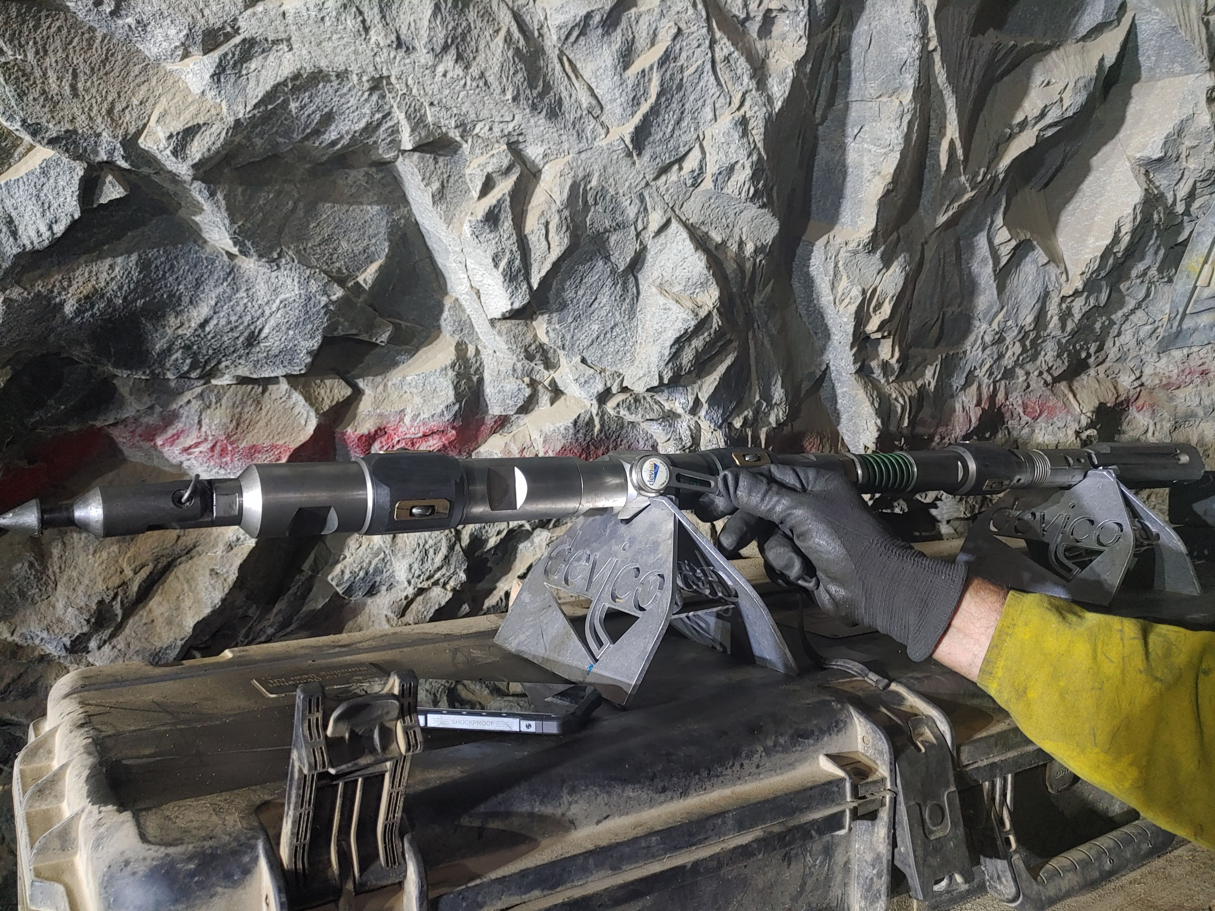
Devico produced the miniature (literally pocket-sized) continuous rate gyro sensor and then developed multiple purpose-built running gear configurations to suit a range of drilling applications. The Overshot Xpress (known as The OX) was one such configuration that proved the right survey solution can truly have a positive impact at the drill rig.
Designed to be compact for confined spaces and extremely rugged for underground environments, the OX enables surveying (up to 100m/min) whilst pulling core tubes, effectively integrating surveying into the diamond drilling process.
As Devico's Global Sales Manager Alex Butler describes it, ''the OX is not a survey tool that is just adapted to be used in over-shot surveying mode - it’s built just for it.''


The interchangeability and strength of each DeviGyro setup keeps the delicate (and costly) sensor protected to make for easy swap-outs, lower repair requirements, and because we've rarely seen a damaged DeviGyro itself, our rental clients aren't impacted by unforeseen costs.


DeviGyro Overshot Xpress
Accurate, convenient, robust and fast is how we sum up the DeviGyro Overshot Xpress, so it's no wonder it's our go-to for surveying in diamond drill holes.
Combining the highly accurate miniature rate DeviGyro sensor with an extremely rugged overshot running gear configuration, the OX enables continuous surveying whilst pulling core tube to maximise bit on bottom time.
Just some of the benefits of the OX include:
- Travels in one transport case - no at-rig assembly required
- Just 1.2m in length - safe for handling by one operator
- Magnetic activation - completely wireless
- Interchangeable centralisers (BQ-NQ with OX Mini or NQ-PQ with OX Standard)
DeviCounter
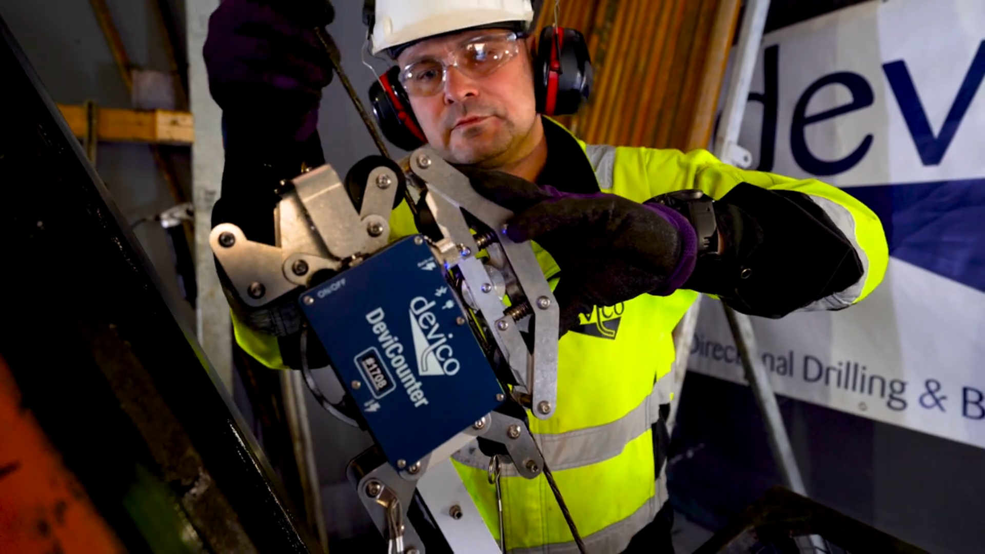
Part of any complete DeviGyro system where continuous surveying is involved, the DeviCounter is a wireless depth counter that is placed on the rig's wireline to record depth as the DeviGyro is deployed. Data is matched with gyro data to provide a highly accurate hole trace.
However as further testament to the continuous improvements made by Devico across their product range, a feature called Automatic Depth Estimation (ADE) was released this year to enable continuous surveying up to 500m without using the Devicounter. ADE now provides drilling and geology teams with the option to save on time and maintenance, without compromising on accuracy.

Data Management
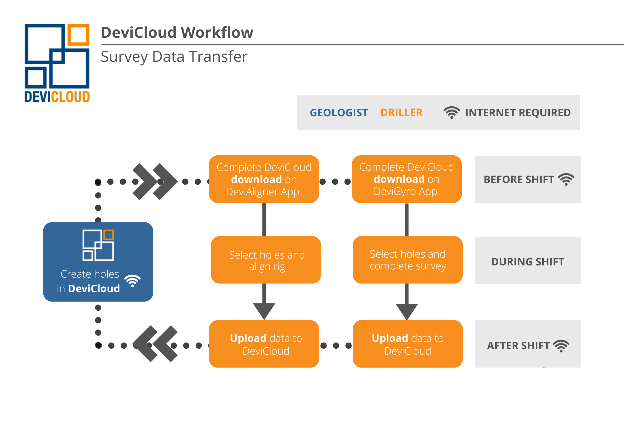
Data management has fast become a crucial component to just about any system, especially now for advanced survey instrumentation. A good survey data management system will connect products wirelessly, streamlining the data transfer process to make each user's job, whether Driller, Geologist or Engineer, easier. The system should make data transparent, secure and be simple to use, which is exactly how we describe DeviCloud.
DeviCloud is Devico's cloud-based survey data management system provided complimentary with every compatible rental or purchase. Much more than just a data depository, DeviCloud follows a thoughtfully curated workflow to minimise manual entry and associated common errors, whilst delivering features and improvements that continue to make data more accurate and the surveying process more productive in general.

When DeviCloud is used to its full advantage, clients benefit from:
- Data quality and confidence: As DeviGyro surveys are run continuously from 0m to depth at selected intervals (e.g. 0-30m, 0-60m), each drill hole ends up with multiple surveys that can be combined into one very precise averaged trace. With each run providing a comparison to the next, this also gives Geologists confidence in their surveys and allows for outliers to be removed from the final average without compromising on the amount of quality data.
- Remote and proactive technical support and monitoring: DeviCloud gives Downhole Surveys the ability to monitor every site and pinpoint common issues that occur, allowing us to help our customers when (or before they know) they need it. We're able to identify room for improvement (think better centralisation or rotation), when maintenance or a tool swap out is required, or even when operators might need a bit more training.
- Added (and endless) features: With 2D and 3D plotting capabilities, comprehensive QA reports, statuses for organising data and more, DeviCloud has so many features to enhance the system's product benefits, and Devico are always working on what improvement they can make next. Sites can now set deviation tolerances on their projects and individual holes, take advantage of automatic depth estimation, and even use the natural deviation calculator to visually project drill paths.
The Method
Best Practice
Because Devico have developed their products to be so versatile, there are options to choose from when deciding how to run the DeviGyro Overshot Xpress complete system. When it comes to maximum quality assurance and overall efficiency however, there are a few we recommend treating as non-negotiable.
- Continuous surveying: Whilst the DeviGyro can be used to conduct multishot surveys, continuous surveying offers far more accuracy and a true hole path trace because it's recording 10 data points per second. Continuous DeviGyro surveys can even pickup changes in ground lithology such as when a hole is drilled through a shear zone. Multishot surveys on the other hand provide no comparison runs and exclude complete sections of data.
Where productivity is priority and not using a DeviCounter is preferred, we recommend using ADE versus opting to do multishot surveys.
- Surveying in regular intervals from 0m: It is intended that DeviGyro surveys are conducted from 0m at regular drilling intervals (30-50m is standard industry practice). This results in a highly transparent data set, where runs can be averaged to become ultra-accurate, and any outliers can be omitted.
- Using DeviCloud: In addition to streamlining the entire survey process, DeviCloud limits errors associated with manual entry and provides clients with remote support and monitoring.
- Tool centralisation and rotation: Tool centralisation is essential to maintaining true hole path trajectory as an uncentralised tool will lay on the low side of the borehole and can 'rock and roll', causing gyro saturation and inaccurate calculations.
It's also critical to introduce consistent tool rotation down the drill hole to zero out bias error internally and with assembly by enforcing continuous tool-face change.
Devico use a patented self-rotating centraliser that forces the assembly to rotate at a fixed rate, whilst maintaining an absolute central path. Centralisers on the Overshot Xpress are also purpose-built to allow changing between drill rod sizes (NQ-PQ for standard, and BQ-NQ for the OX Mini).
- Calibration: All DeviGyros are calibrated in an extremely controlled environment at Devico's headquarters in Norway. Calibration checks are then conducted at DHS depots using a purpose-built DeviHealth stand and software.
DHS also recommends horizontal roll checks are completed on site to check for gyro calibration and tool barrel straightness.
- Drift checks: Drift checks at regular intervals can also help to compensate some tool bias and gyro drift. Drift checks are conducted automatically during each DeviGyro survey as the app prompts operators to keep the instrument still for 10 seconds every 400 seconds, and at the beginning of the survey run.
- Maintenance: DHS provides maintenance training and checklists so that operators are fully equipped to look after their survey instrumentation. This is ultimately crucial for operator safety, equipment longevity and data accuracy.
Understanding Tool Bias
''For most reference gyro instruments, uncompensated bias is the number one enemy against good survey data'' Rune Lindhjem - Senior Technical Advisor, Devico
Tool bias refers to the internal and assembly bias error associated with sensor accuracy, build alignment and barrel straightness. In all gyro instruments, it can cause azimuth offsets and error build ups in survey data.
Calibration, tool rotation and drift checks are the ways in which tool bias is compensated for in the DeviGyro.
Read Downhole Gyros Explained to understand more about tool bias and how it affects different gyro types.
Grids
What about grids?
Prior to commencing any drilling, a grid should be selected, checked and validated.
Having seen many incorrect or out of date grid transformations provided to us, DHS always reviews site grids prior to dispatching equipment by checking against the site's latitude and longitude, and using the Geoscience Australia-Geodetic Calculator to determine the grid convergence. The site grid is then entered into DeviCloud and seamlessly updates surveys to that grid. Once setup, it should never change.
Also a cartographer by trade, Mike Ayris shares his knowledge and recommendations on the topic:
- True north is to always be drawn straight up the page and all grids relate to true. You'd be surprised how many times I see sites get this wrong.
- My recommendation in Australia is to always use MGA and the latest version is 2020. Some sites are still using MGA94 which is now out of date. Never use magnetic north as a grid.
- As discussed earlier we recommend using the DeviGyro and DeviAligner combination which when combined, is a true north seeking system. To convert from True to MGA2020 we apply the grid convergence angle.

%20(2).png)

