Guide to DeviCloud

Survey Data Management

Transparency. Security. Simplicity.

That's survey data manged with DeviCloud

DeviCloud is a cloud-based system compatible with Devico survey instrumentation that streamlines the way survey data is uploaded, transferred and managed in a central platform.


DeviCloud workflow


Data transfer

The DeviCloud workflow has been designed to enable a seamless transfer of survey data from site to the office and to minimise the need for manual entry at the rig.

New or updated hole plans are downloaded before shift for pre-selection, and then uploaded to DeviCloud at end of shift.


DeviCloud workflow


Rig alignment/collar reference shots

DeviCloud uses the following hierarchy to set the starting direction on surveys.

Note: Once any DeviAligner rig alignment shots have been uploaded to DeviCloud, hole data must be downloaded in DeviGyro App to have this information sync and update.

If only a planned direction exists, then this is the starting direction that the DeviGyro app
will import for that hole.

If one rig alignment shot exists on the hole (either uploaded from the DeviAligner or manually specified), it takes precedence over the planned Azimuth.

The rig-alignment shot will be the starting direction that is imported into the DeviGyro app for that hole.

If multiple rig alignment shots exist on a hole, the most recent shot will be imported as
the valid starting direction.

If a rig-alignment shot is set as ‘active’ in DeviCloud, it will be used by the DeviGyro app
even if newer data exists.


Managing data in DeviCloud


Uploading hole plans

DeviCloud allows users to easily upload bulk hole plans with a standard template or individually. Holes are then visible from all site, project and drill program dashboards.

When selected by the driller, hole information is automatically synced to survey results.

New! Holes (including curved designs) can now also be imported using coordinates instead of directions. For instructions and import template, select the symbol next to Batch Import when creating new holes.

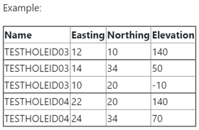
When importing in this format, each hole will span several rows as shown below.

Coordinates can then be edited or added to in the hole dashboard by toggling the editing tools.

Coordinates hole plan
Coordinates hole plan EDITING-1

Organising and archiving survey data

DeviCloud follows a Site > Project > Drill program > Hole format to keep survey data organised and easily accessible by Drillers, Geologists and Engineers.

organise workflow

Statuses can be set on sites, projects, drill programs and holes to easily organise and separate planned, completed and archived drilling.


Setting survey acceptance rules

Survey acceptance rules can be used to set visual deviation tolerances on drill holes either as a percentage of hole depth or as a fixed value. 

survey acceptance plot


Analysing data in DeviCloud


DeviCloud greatly improves the transparency of survey data by making survey quality and results immediately visible in the platform, with comprehensive reporting capabilities.

Learn how to review surveys, analyse results, produce QA reports and use features such as the oscillation filter and weighted averaging.


New! Automatic Depth Estimation (ADE)

ADE is a DeviGyro feature that enables continuous estimation of the hole trajectory when not using the DeviCounter.

Learn more about how and when to use ADE. 


Ready to achieve absolute precision on your next drill campaign?

Contact Us